Comma - Meteorological Physical Background
by ZAMG and KNMI
The typical horizontal scale of Commas is 200 to 1000 km and their duration can range from several hours to two days.
Here are different types of Comma development:
- Within cold air either
- as further development of Enhanced Cumulus cloudiness or
- as Polar Lows
- As a cut off from a mature and well developed Occlusion spiral
- There are a few other developments from Cold Air Development (CAD) and Baroclinic Boundaries. They are regarded as exceptions and are not addressed further here.
Development of Commas within cold air
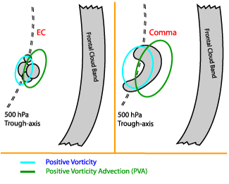
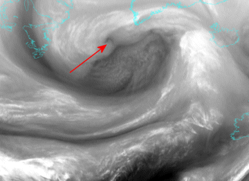
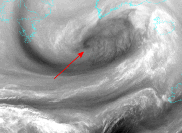
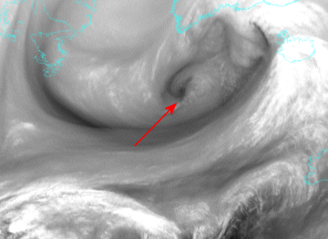
The classical development within cold air masses is the most common. A typical life cycle is shown below using a sequence of satellite images (interval one hour).The development starts from Enhanced Cumulus cloudiness (see Enhanced Cumulus ) which is increasing and, under the influence of vorticity, and finally forms into the typical Comma spiral shape with a Comma head and a Comma tail. This happens mostly in the cold air behind a frontal cloud band under the influence of vorticity and positive vorticity advection.
|
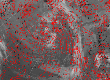
25 April 2005/00.00 UTC - Meteosat 8 IR 10.8 image; red: vorticity advection 500 hPa
|
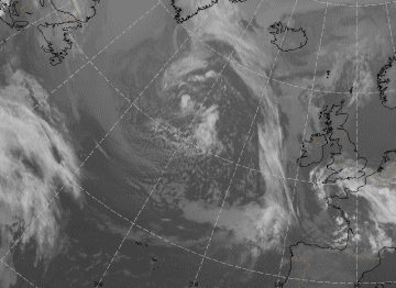
25 April 2005/03.00 UTC - Meteosat 8 IR 10.8 image
|
|
|
|
|
|
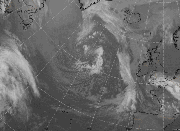
25 April 2005/06.00 UTC - Meteosat 8 IR 10.8 image
|
Baroclinic instability
One theory focuses on baroclinic instability. Although baroclinic instability is regarded as a larger scale phenomenon, it can also be used for explaining smaller systems.Baroclinic waves with a wave length of about 3000 to 4000 km usually show a rapid rate of growth. If parameters such as vertical wind shear (large horizontal temperature gradient) and static stability are taken into account, disturbances with much shorter wave length can also grow rapidly if a jet streak is involved. (For more details see Reed, 1979)
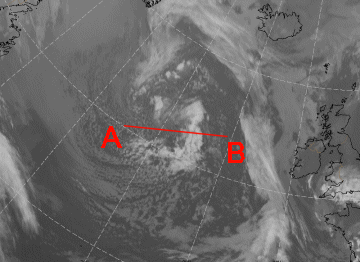
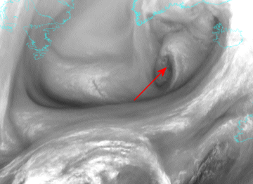
Many case studies of Commas made at ZAMG (more than 50) showed baroclinity at high levels which would support this theory. One example is shown below.
|
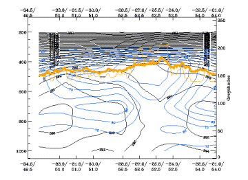
25 April 2005/06.00 UTC - Meteosat 8 IR 10.8 image; position of vertical cross section indicated
|
25 April 2005/06.00 UTC - Vertical cross section; black: isentropes (ThetaE), blue: relative humidity, orange
thin: IR pixel values, orange thick: WV pixel values
|
|
|
Barotropic instability
Barotropic instability should also be taken into account when considering a Comma formation. Commas develop on the left side of the polar jet axis. The problem with this theory is the scale: The wavelength of maximum instability is about four times the half-width of the jet. If a Comma (Polar Low) is assumed to have a wavelength of 1000 km the jet would not normally be broader than 250 km in half-width, which is unrealistically small. (For more details see Reed, 1979).Case studies found in the literature, as well as the ones studied at ZAMG, support this theory with respect to the location of the Comma on the left (cyclonic) side of the jet.
So both theories can explain some features of Comma development but are not totally satisfactory.
CISK mechanism
Another theory is Conditional Instability of the Second Kind (CISK) which focuses on the unstable convective characteristic of the Comma phenomenon. The underlying assumption of this theory states that cumulonimbus convection alone cannot maintain the low-level convergence necessary for the development of clouds. Therefore large scale convergence is also essential. If an air parcel rises in a conditionally unstable, unsaturated air mass, it will give rise to cumulonimbus convection because of the release of latent heat. The vertical distribution of the wind field (low level convergence and high level divergence) results in a convergence of moisture in the boundary layer and an increase of cyclonic vorticity. As a consequence vertical velocity will increase at the top of the Ekman layer. Now a positive feed-back loop is established which amplifies convection as well as the large-scale convergence. This theory was developed for tropical cyclones as the atmosphere normally is (conditionally) unstable at lower latitudes. In several aspects this process is also true for other regions, e.g. if cold polar air streams over a relative warm sea surface.This theory is supported by those cases where a Comma develops from an EC area far behind the frontal cloud band.
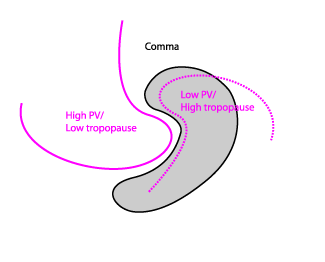
Potential vorticity
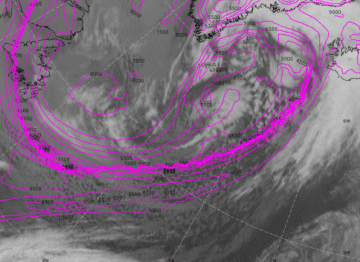
Another interesting point of view is the role of potential vorticity (PV). If there is an upper tropospheric PV maximum rising motion occurs at the leading edge - assuming the PV maximum is sinking. There is also a region of reduced static stability there. If a major incursion of high PV overruns a region of moist air and strong baroclinity it leads to cyclogenesis, especially if the induced upward motion ahead of the PV anomaly becomes moist and diabatic effects are involved. (For more details see Browning, 1993)This theory is supported in the case studies by the fact that a very large number of Commas are associated with a PV anomaly, represented by a very low height of the PV=2 surface, which corresponds to the transition between tropospheric and stratospheric air.
|
07 December 2004/18.00 UTC - Meteosat 8 IR 10.8 image; magenta: Height of PV=2 units
|
|
|
|
Further development
Commas, once developed, can be involved in or can be the starting point of other conceptual models such as Instant Occlusion (see Instant Occlusion ) or Cold Air Development (see Cold Air Development ).
Development of Commas from Occlusion spirals
If an Occlusion is accompanied by a very intensive, pronounced cloud spiral the innermost part can become separated, i.e. the connection between the Occlusion spiral and the rest of the cloud spiral becomes an area of only shallow cloudiness and finally disappears so that the remaining Comma cloud becomes a separate feature. Sometimes the innermost part of the Occlusion cloud band disappears and a Comma develops in the cloud-free area. Nevertheless its origin is the Occlusion spiral.The area where this separation happens is the north-western part of the Occlusion cloud band which disappears as a result of negative vorticity advection and divergence in lower levels. This happens to the rear of the upper level low or trough. In contrast, the innermost part of the Occlusion cloud spiral lies in an area with positive vorticity advection and sometimes within an area of convective activity. Therefore, this is an area where cloudiness can become enhanced.
A Comma which is generated by an Occlusion is shown by the following sequence of satellite images (interval six hours). Such a development is no less frequent than the development of Commas within cold air mentioned above.
|
07 December 2004/06.00 UTC - Meteosat 8 WV 6.2 image
|
07 December 2004/12.00 UTC - Meteosat 8 WV 6.2 image
|
|
|
|
|
|
07 December 2004/18.00 UTC - Meteosat 8 WV 6.2 image
|
08 December 2004/00.00 UTC - Meteosat 8 WV 6.2 image
|
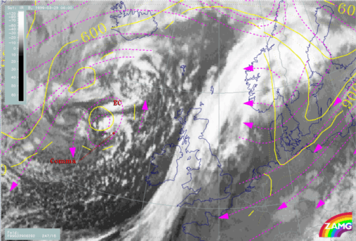
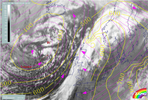
Relative streams and Commas
From the viewpoint of conveyor belt theory, Commas usually lie within one single air mass, the dry intrusion.Relative streams related to Commas show a characteristic pattern, namely, an isolated cyclonic circulation around the cloud spiral with upward motion within the cloudiness and descending motion behind. This circulation can be observed at all levels above the unstable air mass, up to the tropopause and does not change much between different levels. Only vertical motion is decreasing with height. In the case of Commas without specific circulation, a pronounced cyclonic curvature of the streamlines can usually be found.

|
29 March 1999/06.00 UTC - Meteosat IR image; magenta: relative streams 282K - system velocity: 247° 16 m/s, yellow:
isobars 282K
|
29 March 1999/06.00 UTC - Meteosat IR image; magenta: relative streams 300K - system velocity: 247° 16 m/s, yellow:
isobars 300K
|
|
|


