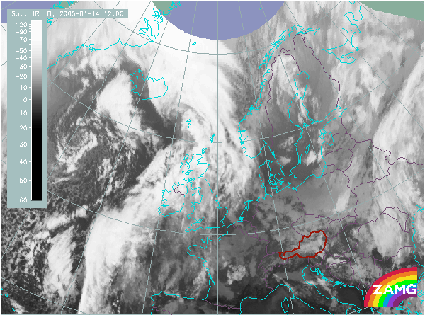
Does this actual case reflect the conceptual model well? Compare the ideal configuration!
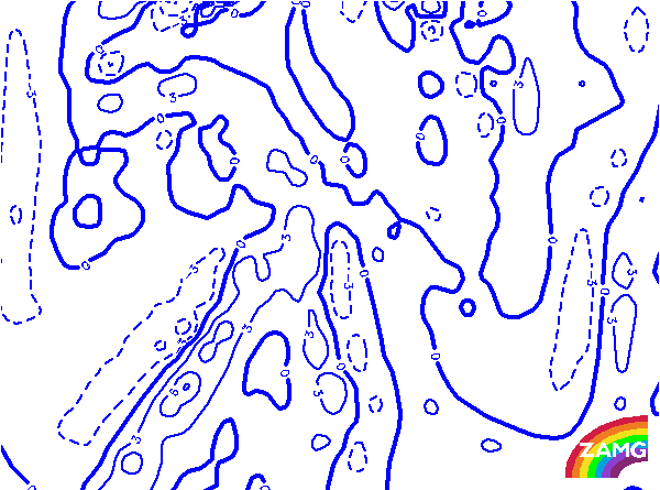
Height Contours 1000 hPa:
There are two main surface minima: the northern one is behind the frontal cloud band, the southern one is in the area of the frontal Wave bulge. Both Comma features which are so large that they can be regarded as candidates for the conceptual model of a Cold Air Development are also in the area of these height minima. This is in good agreement with the ideal situation.
There are two main surface minima: the northern one is behind the frontal cloud band, the southern one is in the area of the frontal Wave bulge. Both Comma features which are so large that they can be regarded as candidates for the conceptual model of a Cold Air Development are also in the area of these height minima. This is in good agreement with the ideal situation.
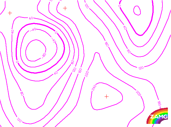
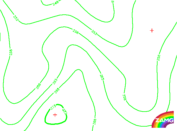
Height Contours 500 hPa:
The two areas of a possible Cold Air Development are within a huge upper level trough at the rear side of the frontal cloud band. Both cloud features are more at the rear side of the trough which is not exactly there where it is expected in an ideal case, namely in the minimum of the trough. But in this case the upper level trough is far advanced and is partly even superimposed on the frontal cloud band which is also not very typical.
The two areas of a possible Cold Air Development are within a huge upper level trough at the rear side of the frontal cloud band. Both cloud features are more at the rear side of the trough which is not exactly there where it is expected in an ideal case, namely in the minimum of the trough. But in this case the upper level trough is far advanced and is partly even superimposed on the frontal cloud band which is also not very typical.
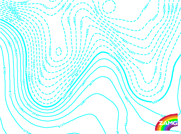
Isotachs 300 hPa:
There is a huge jet streak along the rear side of the frontal cloud band. Both large Commas which can be regarded as Cold Air Developments are on the cyclonic side of this jet streak and for both systems the Comma tails reach into the jet streak area. This is very close to the ideal configuration in this conceptual model.
There is a huge jet streak along the rear side of the frontal cloud band. Both large Commas which can be regarded as Cold Air Developments are on the cyclonic side of this jet streak and for both systems the Comma tails reach into the jet streak area. This is very close to the ideal configuration in this conceptual model.
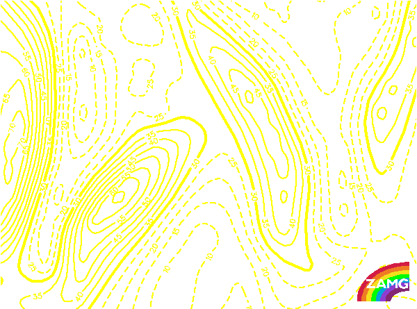
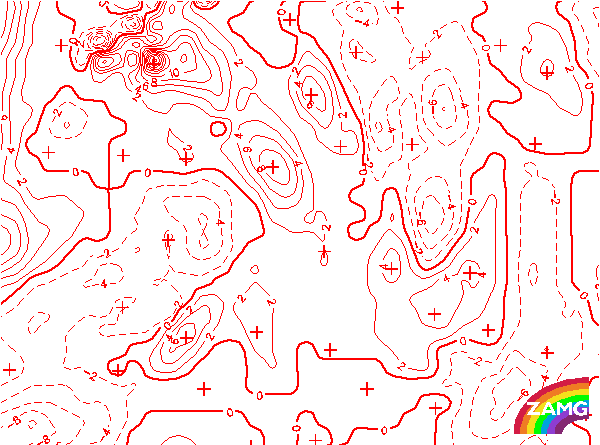
PVA 500 hPa:
There are distinct PVA maxima in the area of the two Commas respectively Cold Air Development features. They are in the area of the Comma tails as is expected in the typical situation. In this special case both PVA maxima are somewhat shifted in the direction of the frontal cloud band which is a speciality of this case as the Comma/CAD features are very close to the frontal cloud band.
There are distinct PVA maxima in the area of the two Commas respectively Cold Air Development features. They are in the area of the Comma tails as is expected in the typical situation. In this special case both PVA maxima are somewhat shifted in the direction of the frontal cloud band which is a speciality of this case as the Comma/CAD features are very close to the frontal cloud band.
TFP:
A distinct TFP is related to the frontal cloud band and not to the Commas/CAD features. Only the northern feature of the two shows an area were a secondary TFP could develop or strengthen. The situation is in agreement with the typically expected configuration.
A distinct TFP is related to the frontal cloud band and not to the Commas/CAD features. Only the northern feature of the two shows an area were a secondary TFP could develop or strengthen. The situation is in agreement with the typically expected configuration.
Equivalent Thickness:
The configuration of thickness clearly shows the frontal transition zone and the thickness ridge of the Occlusion. The large Commas or beginning Cold Air Developments are in different relations to the thickness gradient. The northern system is within the thickness ridge - a site which is not very typical for a Cold Air Development; the southern system however is already connected to a broad zone of high thickness gradients. This seems to be a sign for a further development and is typical for such a conceptual model.
The configuration of thickness clearly shows the frontal transition zone and the thickness ridge of the Occlusion. The large Commas or beginning Cold Air Developments are in different relations to the thickness gradient. The northern system is within the thickness ridge - a site which is not very typical for a Cold Air Development; the southern system however is already connected to a broad zone of high thickness gradients. This seems to be a sign for a further development and is typical for such a conceptual model.
Temperature Advection 700 hPa:
As also in other parameters like for instance in TFP and thickness configuration, there are differences between the two large Commas/CADs. The southern one is still within CA, the northern one is influenced by the large scale WA in connection with the Occlusion. Both configurations do not contradict such a conceptual model, but the one with the southern Comma is more typical.
As also in other parameters like for instance in TFP and thickness configuration, there are differences between the two large Commas/CADs. The southern one is still within CA, the northern one is influenced by the large scale WA in connection with the Occlusion. Both configurations do not contradict such a conceptual model, but the one with the southern Comma is more typical.