Does this actual case reflect the conceptual model well? Compare the
ideal configuration!
The position of the Vertical Cross Section is indicated in the following image:
VCS Position
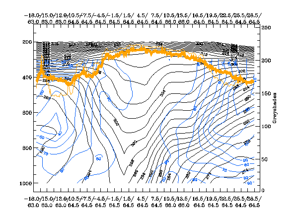
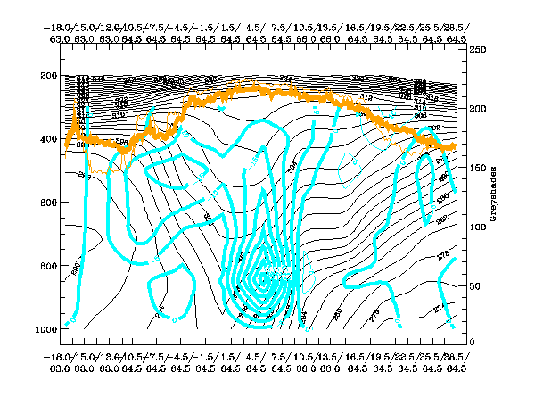
Relative Humidity:
The cloud of the Wave can be recognised within the downward inclined zone of high gradients in the isentropes. It is within the transition area of high to low values of humidity. There is especially high humidity in the higher levls while in lower levels the dry air at the rear can already clearly be recognised. However, the even more pronounced area of high humidity is connected to the Warm Front Shield which covers the biggest part of the vertical cross section.
The cloud of the Wave can be recognised within the downward inclined zone of high gradients in the isentropes. It is within the transition area of high to low values of humidity. There is especially high humidity in the higher levls while in lower levels the dry air at the rear can already clearly be recognised. However, the even more pronounced area of high humidity is connected to the Warm Front Shield which covers the biggest part of the vertical cross section.
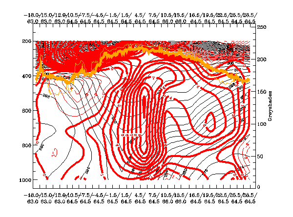
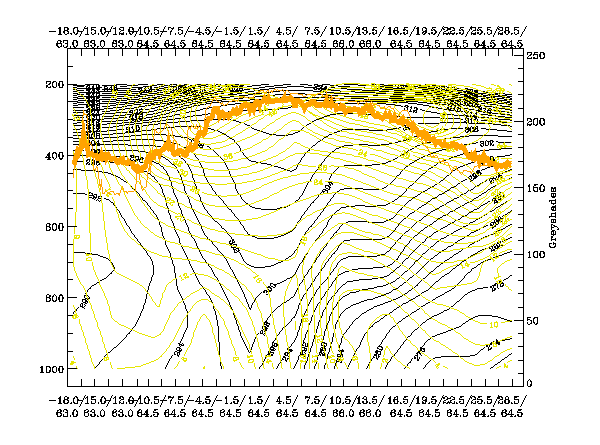
Temperature Advection:
The vertical distribution of isolines of temperature advection show, first of all, the extended area of WA associated with the Warm Front Shield. At the Cold Front, there is WA in low and middle levels (up to about 650 hPa) in the area of the Wave and distinct CA above. This deviates somewhat from the usual distribution of this parameter, where WA is above the whole frontal zone. But it does not contradict the conceptual model of a Wave.
The vertical distribution of isolines of temperature advection show, first of all, the extended area of WA associated with the Warm Front Shield. At the Cold Front, there is WA in low and middle levels (up to about 650 hPa) in the area of the Wave and distinct CA above. This deviates somewhat from the usual distribution of this parameter, where WA is above the whole frontal zone. But it does not contradict the conceptual model of a Wave.
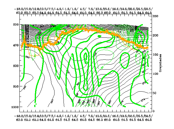
PVA:
There is an extended area of PVA in the whole frontal zone. But the important region for the conceptual model of a Wave is the one in high levels (around 300 hPa) which is over and a bit behind the cloud bulge of the Wave. This is in agreement with the classical ideas.
There is an extended area of PVA in the whole frontal zone. But the important region for the conceptual model of a Wave is the one in high levels (around 300 hPa) which is over and a bit behind the cloud bulge of the Wave. This is in agreement with the classical ideas.
Vertical Motion (Omega):
As also determined for other parameters in this vertical cross section, there are main signals, namely intensive upward motion, together with the extended Warm Front Shield cloudiness. The interesting area of upward motion for the Wave area can be found from about 800 to 400 hPa while there is already sinking in the lower layer below the frontal surface. This is in good agreement with the expected ideal configurations.
As also determined for other parameters in this vertical cross section, there are main signals, namely intensive upward motion, together with the extended Warm Front Shield cloudiness. The interesting area of upward motion for the Wave area can be found from about 800 to 400 hPa while there is already sinking in the lower layer below the frontal surface. This is in good agreement with the expected ideal configurations.
Isotachs:
In this case the jet axis is somewhat ahead of the cloud bulge of the Wave and, consequently, the Wave lies on the cyclonic side of the jet streak. This deviates from the ideal configuration in which the jet axis should be along the rear of the Wave bulge. This is also a key feature for an Occlusion of the Warm Conveyor Belt type which is not the case here. Nevertheless, the further development of the Wave is very typical and the rather darker grey shades of the cloud bulge in this case is in agreement with the overrunning drier air.
In this case the jet axis is somewhat ahead of the cloud bulge of the Wave and, consequently, the Wave lies on the cyclonic side of the jet streak. This deviates from the ideal configuration in which the jet axis should be along the rear of the Wave bulge. This is also a key feature for an Occlusion of the Warm Conveyor Belt type which is not the case here. Nevertheless, the further development of the Wave is very typical and the rather darker grey shades of the cloud bulge in this case is in agreement with the overrunning drier air.